In a groundbreaking scientific advancement, researchers from Google and the University of Colorado Boulder have transformed millions of Android smartphones into powerful scientific instruments, creating the most detailed map of Earth's upper atmosphere to date.
The innovative project leverages GPS sensors built into Android phones to collect data about how Earth's atmosphere affects satellite signals. This crowdsourced approach has produced unprecedented insights into the ionosphere - a dynamic layer of the atmosphere extending over 350 miles above Earth's surface.
"These phones can literally fit in your palm," explains Dr. Jade Morton from the University of Colorado Boulder. "But through crowdsourcing, we can use them to change the way we understand the space environment."
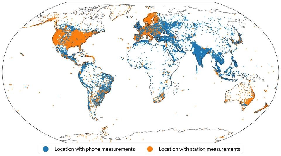
The ionosphere poses unique challenges for GPS accuracy because it contains charged particles that affect satellite signals. Traditional monitoring methods, using ground-based radar stations, can only observe about 14% of the ionosphere at any given time. This limitation can result in GPS location errors ranging from a few feet to several dozen feet.
By harnessing data from Android phones worldwide, researchers achieved approximately 21% coverage of the ionosphere - nearly doubling the observation capability of conventional methods. "Smartphone-based measurements cover twice as much of the ionosphere as traditional scientific monitoring stations," notes Brian Williams from Google Research.
The project captured remarkable atmospheric phenomena, including the formation of "plasma bubbles" - large regions containing low concentrations of charged particles - above South America during a solar storm in May 2024. These bubbles were observed rising through the atmosphere in unprecedented detail.
The research team emphasized privacy protection throughout the study. The ionosphere maps were created using aggregated measurements that cannot identify individual devices or users.
This innovative use of everyday technology could lead to substantial improvements in GPS accuracy worldwide, benefiting applications requiring precise location data, such as aircraft navigation systems.
The study demonstrates how common devices can be transformed into valuable scientific tools, opening new possibilities for understanding our planet's atmosphere while improving everyday navigation technology.